Access an Extraordinary New Dataset on Long-Term U.S. Weather Patterns

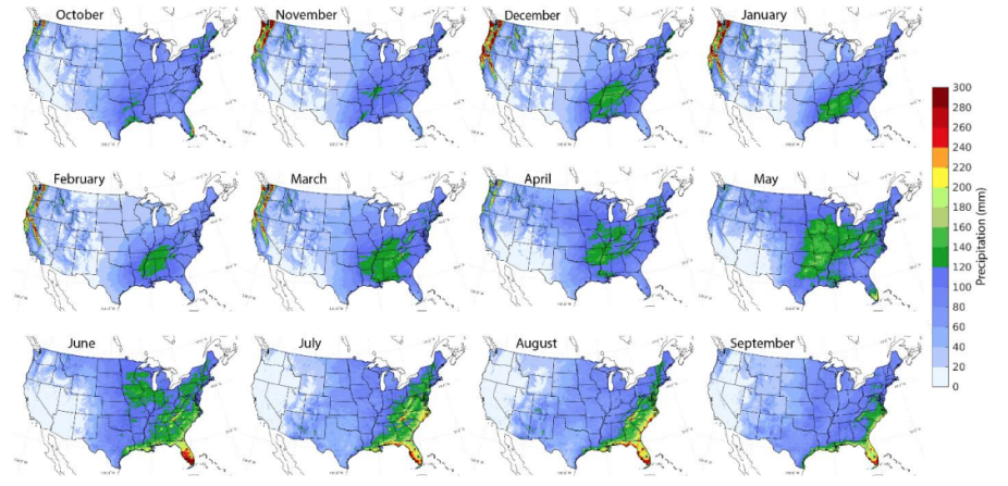
CONUS404 monthly precipitation climatology from 1986-2020.
Researchers can now access CONUS404, an unprecedented dataset offering high-resolution weather simulations.
The nearly one-petabyte dataset is the result of a collaboration between the National Center for Atmospheric Research (NCAR) and the U.S. Geological Survey (USGS) and was recently published in NCAR’s Research Data Archive (RDA).
To create this dataset, the USGS partnered with NCAR to “downscale” one of the most widely used global reanalysis datasets, called ERA5, to create a high-resolution dataset for the contiguous United States (CONUS) covering more than 40 years (1980–2021) at 4-kilometer grid spacing—hence the name CONUS404.
Scientists are using the data to explore new techniques for improving long-range forecasting, planning for water resource allocation, and to better understand the causes and impacts of extreme and rare weather events. The data also demonstrates how weather patterns may have already shifted as the climate warms.
The dataset took almost a year’s worth of supercomputing time to create. A dataset covering such a large area over such a long time at such a high resolution has never before been feasible, but recent advances in both supercomputing and weather models have made it possible.
CONUS404 provides more detailed weather analysis than previous datasets, since its grid points are separated by only 4 kilometers (2.5 miles)—as opposed to 30 kilometers (19 miles)—yielding information that is more granular and accurate than previous models.
“With CONUS404 it is possible to study both long-term events that can stretch for many years, like droughts, and rare events that don’t last long but rarely occur, like extreme floods,” said Roy Rasmussen, the NCAR senior scientist who led the project.
To learn more about the CONUS404 dataset, read the full article. NCAR also offers Data Analysis allocations to allow researchers to access and analyze CONUS404 using the Casper analysis cluster.